 |
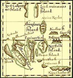
This map appears on the final page of Basil Ringrose's The South Sea Waggoner. Although the Waggoner was written ca. 1682, this Galápagos map was added to it by an unknown hand at some point after 1686, as may be proven by the following considerations:
- James succeeded to the throne in February, 1685.
- Basil Ringrose died in February, 1686.
- William Cowley returned to England in October, 1686 and at some point thereafter prepared his own journal for publication, in which he renamed his Duke of York's Island as King James Island.
- The name King James Island appears on this map.
|
 |
This map appears in Morgan Ms. 3310, Section II. The ms. appears to be the one used in the preparation of Cowley's Voyage … which was published in 1699. |
 |
This map by Herman Moll appears as an insert at page 9 of the 1699 English edition of Cowley's Voyage …, with a revised version, “Les Isles de Gallapagos,” in a French edition Voyage aux Terres Australes, A La Nouvelle Hollande published in 1723 by Jean-Baptiste Machuel. |
 |
Moll's map (above) was subsequently redrawn by Emanuel Bowen for publication in the second and third editions of the John Harris Navigantium …. |
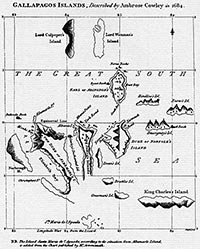 |
James Burney noted that James Colnett “… saw land due South of King James's Island, …and appears to have mistaken [it] for the King Charles's Island of Cowley's chart …” Colnett then re-named Cowley's actual Charles (the modern San Cristóbal) as Chatham. The island Colnett saw was in fact unknown to Cowley but called Santa María by the Spaniards. Accordingly, John Russell (Burney's engraver) added the island to Cowley's chart and appended Burney's explanation immediately below. The correction appears to have been overlooked by subsequent historians, many of whom continue to associate Charles with the present Santa María/Floreana, when in fact it should be linked to the present San Cristóbal. |