14
15
16
17
18
19
20
21,
22,
23
24
25,
26,
27
28
29
30
1
2
3
4
5
6
7
8,
9
10
11,
12
13
14
15,
16
17
18
19
20,
21
September Dates
October Dates

- Use radio buttons at upper left to select desired document.
- Click any date on map to view selected document's entry for that date.
- Use day and date links within any document to switch to other document entries for that date. See instructions at top of each document page for more details.
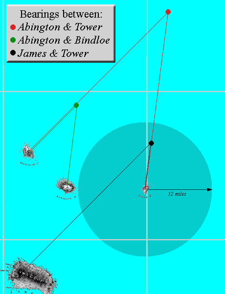
6 October Bearings
The three sets of bearings (red, green, black ) indicate three possible positions of the Beagle at noon, as follows:
Red: This set applies the bearings to the island names as stated in the logs.
Green: This set assumes that the bearing to Tower was in fact to Bindloe.
Black: This set assumes that the bearing to Abington was in fact to James.
As written in the logs and shown in red on the detail view, the bearings to Abington and Tower place the Beagle far to the north—and well beyond the 32-mile visibility limit—of Tower Island. It is therefore apparent that the name of at least one of these islands was written in error. If Tower should have been written as Bindloe, then the green set is correct. However, if Abington should have been written as James, then the black set is correct and this seems more likely. It places the Beagle well within Tower's visibility limit, and agrees with subsequent bearings to Tower taken later in the day.


Click image to display
other possible positions.


Admiralty Chart L945
The zig-zag track to the northeast of Chatham island is followed by a lengthy segment that takes the Beagle eastward beyond the border of the chart, and then back in again. Yet all three logs show no entries that would support this detour. In fact, FitzRoy's Narrative (Volume II, p. 488) states that the ship “Sailed round the north-east extremity of the island, and worked to the southward against a tide, or rather current, setting strongly to the north-west.” This would suggest that the Beagle worked down the coast of the island, well within sight of the shoreline.
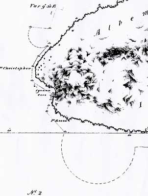
Admiralty Chart L946
An inscribed semi-circle suggests the Beagle took an unusual detour away from the coast and then back again. A similar though smaller semi-circle is also seen to the north of Point Christopher. There is nothing in the logs nor in Volume II of FitzRoy's Narrative to explain these deviations.
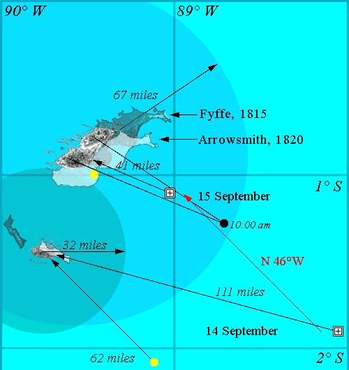
14 September: The noon log entry gives the latitude and longitude as 1°53' S and 88°13' W, as indicated by the  on this detail view. The bearing and distance to Lord Hood's Island are given as N 45° W, and 62 miles, and this position is indicated by a yellow dot. Note that if the Beagle were at the position indicated by the latitude and longtitude, the bearing and distance would in fact be approximately N 72° W and 111 miles.
15 September: The noon log entries are 1°07' S and 89°01' W ( ), and the bearing and distance to Chatham Island are NW and 10 miles (yellow dot). But again the entries are contradictory: if the ship were at the indicated position, the bearing and distance would be about N 70°W and 41 miles. The noon Course entry is given as N 46° W, and this is exactly the course calculated by GPS between the noon bearings taken on 14 and 15 September.